The day had proven to be a good one. On a mid-morning hike at my homestead I was fortunate to see several turkeys and found a red eft. (The land stage of a red-spotted newt.) I, also, enjoyed the vigor of a 2 mile hike.
 However, the most interesting part of the day was a trip to the Parker’s Landing Petroglyph site. This site is about a mile jaunt from the bridge at Parker on the Clarion County side of the Allegheny River. The site is almost across from the mouth of Bear Creek on the Armstrong County side of the river. This is beautiful country!
The reason for this expedition was that Rennatta and Louie of the Leader Times paper of Kittanning wanted to do a story on the Native American rock carvings. I hadn’t been at the site for sometime so I was concerned about the actual location. I was 98% certain, but because others were going the 2% uncertainty had me feeling a little anxious. 
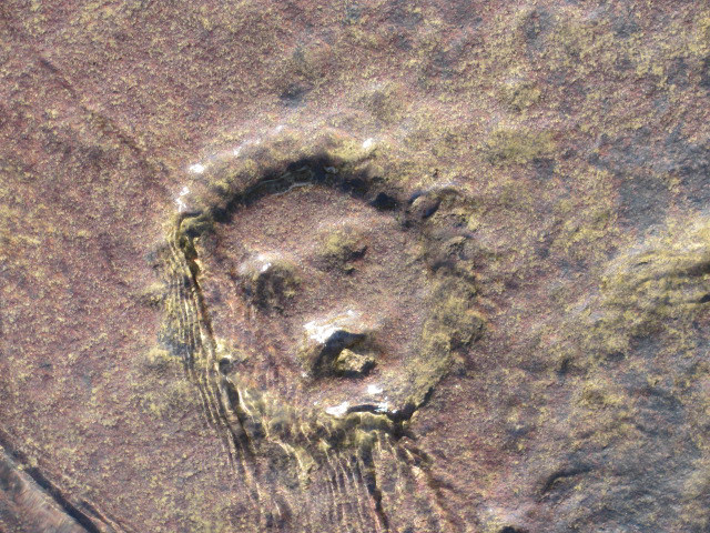
While we were heading south along the river I mentioned that the river seemed to be up some. My observations would prove to be correct. The carvings can only be viewed when the river levels are at their lowest. Apparently, the rains were more intense up-country. Fortunately, one section of rock was exposed and a few petroglyphs could be viewed and photographed.
 The most common theory is that the carvings were completed anywhere from 500 B.C. to 1500 A.D. A few my have been done later because they appear to have been done with metal tools. It is believed a tribe known as the Monongahela Indians may have been the artists. Why? Maybe spiritual in nature…maybe they show boundaries. The truth is we will never know with 100% certainty.


Larry…
I’ve always thought that area was so beautiful,and try to take a drive up there every autumn…I never knew about the petroglyphs…You’ll have to show me the location someday…I’ve always wanted to try the Foxburg Inn, just up the river-I’ve heard they have great food, and a beautiful view of the river while you’re eating…Thanks for sharing another of history’s mystery’s from the area…many people just don’t realize what a rich historical area we live in…
God Bless,
Slim
Slim,
The river gets more beautiful as one travels north. You see waters untouched by dams. Islands, rapids are visible too. The Foxburg Inn is a very nice place to eat. The times I have been there I have always viewed various waterfowl; hawks and vultues flying about. You can watch them, as well as, observe the river while you eat! As for history in our area….history abounds! LAS
Someday take me to check these out to. I’d love to see them.
we would need to ensure that the river is not too high………….but yes, I would take you up!
Larry, can you tell me if there is a way to obtain a copy of the Parkers Landing Petroglyphs print. I really enjoy all of your artwork but this one is special since I live close to this site.
Thank you for any information you can give me.
Linda,
I have some here at my house for $35.00 each. Sometime you are traveling in Kittanning area let me know.
Thank you,
Larry
Thank you so much. I will do that.
The first picture i have a NRA picture of Parker Landing With Indians making that drawing and in a lot of other indians in it
Thank you… that painting was a challenging one for me. I had to do a lot of research as to what may, or may, have not been around the Indians at their time.
One thing people often forget is that any native Americans in this region (north east/great lakes) did have access to some metal tools made of copper. this copper was not gathered locally but traded in a long distance trade network it the tools originating in Michigan which has large reserves of very pure copper close to the surface (float copper). people often underestimate ancient peoples but they were just as intelligent then as we are now just with different tools at their disposal. Obsidian tools originating in Mexico have also been found at sites in the north east. a
Yes, correct…the trade between the Indians and whites had been around a long time.
Larry. My friend and I walked down the dirt road and could not figure out how to get down to the river. It was very steep. Can you walk the edge of the river? How do you get to them?
We wanted to kayak there from Parker’s Landing boat launch but different people told us we wouldn’t be able to kayak back to the launch
Any info would be very much appreciated. The water should be low enough now?
Paula, I haven’t been at the site for quite some time. I hear there has been development along the old tracks road. The river is low and best to see the site. You may be able to walk the shoreline since the river is low but I can’t say just how much vegetation is currently present. At the site there was a path down to the river’s edge.
Larry, do you happen to know what the flow (cfm) of the Allegheny was for the Parker gauge that day?
Dave, I am sorry, but I do not know. The river was low like it has been this summer.(Unless any recent rains north were plentiful.)
Today, September 30th the petroglyphs are easily visible as the Allegheny River flow is 2900 cfs at the Parker gauge.